
Field Name Book description from 1838/1839 noted by the surveyors who produced the O.S maps originally.
B.S.S.M. : 2
Baile Curraoin , Currin’s town.
Rectius Baile Uí Curraidhin, the town of 0’Curreen or Currin.
- Ballycurrin : J. 0’Donovan
- Ballycurrin : Rev: Jas. Geraghty
- Ballicurrin , Ballicurin : Down Survey Maps
- Ballynchurryn : Strafford’s Survey
- Ballacurryne : Inq. temp. Eliz
- Balliecorrin : Inq. temp. Jac. I.
In the west side of the parish. Bounded on the N. and W. by Lough Corrib; S. by Gortbrack td.; and E. by the tds. of Mounthenry, Glasvally and Gortatober.
Placenames
Dooneen
Parks
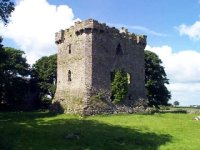
Historical & Archaeological features


NOTE :: This is on private property , owner must give permission for access.
Ecology & Habitats