 Shrule the name given in 1570 by the four masters as Sruthair, the word is a variation of Sruth or Sruthan: a stream or river. The tradition of Shrule deriving it’s name from sruth-fuil, meaning river of blood, because of a massacre at Shrule bridge in 1642 is a fabrication and incorrect, as the name was already in use before that time.
It appears in The Annals of the Four Masters in 1278 . The name took various forms through the centuries, i.e.: Strothyr, Shrure, Shrower, Sruhir, and Shruel…
 The Annals of Shrule were originally compiled by Gerard Metadger and in the past two decades they have been added to and reformatted several times to include new material and to separate information into different categories better suited to presentation on the internet .
The Annals do not include the twentieth century ..
..yet !
The following is an index to the present format .
History of the area from the 1500 to 1900
1850 to 1900 . Local history for the latter half of the 19th century.
1800 to 1850 . Local history of the earlier half of the 19th century including the famine.
1700 to 1800 . Eighteenth century history
1600 to 1700 . Seventeenth century history
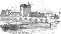
Massacre of Shrule
Massacre of Shrule Bridge (1642)
1500 to 1600 . Sixteenth century history
Battle of Shrule
Battle or massacre of Shrule – 1570
History of the area from the earliest times to 1000 to 1500
1400 to 1500 AD . Local history for the15th century.
1300 to 1400 AD . Local history for the14th century.
1200 to 1300 AD . Local history for the13th century.
1000 to 1200 AD . Local history for the11th and 12th centuries.
History of the area in the first millenium
400 to 1000 AD . Christian Ireland before 1000 AD
1 to 400 AD . After Christ to the coming of St.Patrick
BC . Before Christian Era (BCE)
Maps of the region through history
Maps and their histories for the area
Ordnance Survey . 6″ : 1 Mile
Shrule parish spans 6 inch map numbers 121 , 122 and 123 for Mayo .

1 : 50000 Discovery maps for the area are numbers 38 , 39 , 45 and 46 .
Townland
Index map of the parish and surrounding area showing townlands and placenames.

Down Survey
Map of the area from Hibernia Delineato published in 1685 by Sir William Petty for the Down survey of Ireland .

Clergy who have served in Shrule parish
Church men and women
Shrule priests , curates and friars through the century of Penal laws and persecution.
Landlords seats in the locality.
Dalgan Park
Kirwan – The Kirwan family occupied Dalgan Park from 1760’s to 1853.
De Clifford – Dalgan park was purchased by the Duke of Bedford, from the Russell family . Edward Russell inherited the title of Lord DeClifford.
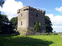
Ballycurran
Maurice Lynch got a lease of Ballicurran Castle and 4 quarters of land on March 1679.
Moyne
Moyne – Occupied by Burkes , Blakes , ffrenchs etc. . .
Shrule House
John and James Golden are said to have built Shrule house in 1769 .
Shrule Grove
Lynch – Pierce Lynch moved to Shrulegrove about 1610 .
NB: 1649-1672 Coin or Token issued by Patrick Lynch of Shruel (Shrewel)
Ormsby – Sir Edward Ormsby moved to Shrulegrove after the departure of Pierce Lynch in 1655.
Glencorrib
Dillon-Brown – The family originally came from further north in county Mayo, they owned what was left of the Mochorrha castle and lands .
Higgins – Captain Fitzgerald-Higgins purchased Glencorrib lodge and the land of Bunafolistrane, now Glencorrib, from the Dillon-Brownes in 1850.
Statistics and general analysis .
Statistics : Lies , damn lies and statistics !
Origins
Surname origins for the area .
Land
Griffiths Valuation , Tithe Applotments and names occurring in each .
Shrule town plan ( 1838 : Griffiths’ Valuation )
