
Field Name Book description from 1838/1839 noted by the surveyors who produced the O.S maps originally.
B.S.S.M. : 7
Brodalach. – Meaning uncertain
- Brodullagh Nth : J. 0’Donovan
- Brodelogh : Down Survey Maps
- Brodullagh ( Brodaghlagh ) : Strafford’s Survey
Situated in the N. side of the parish.It is bounded on the E. by Ramolin td.; S. by the td. of Brodullagh South; W. by Cahernabrock td.; and on the N. by Mocollagan td.
Brodullagh South , a central townland.It is bounded on the N. by the tds. of Cahernabrock, Brodullagh North, and Ramolin; E, by Ramolin td.; S. by the tds. of Cloonbanaun and Kinlough; and W. by Carrowoughteragh td.
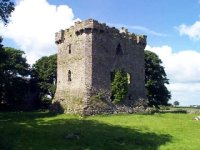
Historical & Archaeological features
Brodella Church


NOTE :: This is on private property , owner must give permission for access.
Some more photos from Kevin Flood


Ecology & Habitats